TODDBORG.COM
TAHOE TOUR
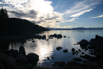
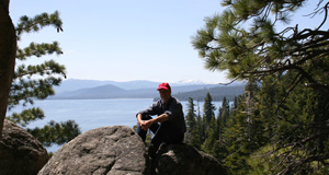
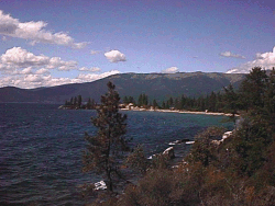
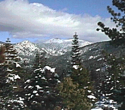
The left photo is a view from the Rubicon Trail, accessed from DL Bliss State Park on the West Shore.
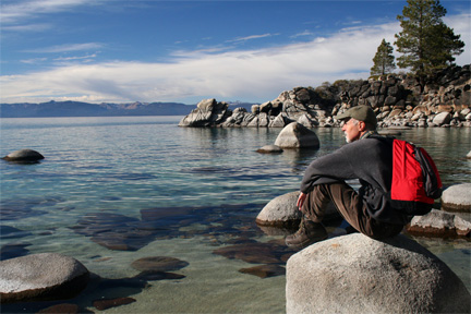
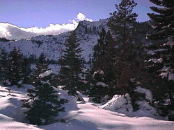
The right photo is near Secret Beach on the East Shore, south of Sand Harbor. You can only get to it by hiking.
| Home |
| Blog |
| Books |
| Events |
| Owen |
| Spot |
| TahoeTour |
| Art |
| Danes |
| Speaking |
| Bio |
| Order |
| Contact |
TAHOE TOUR
|
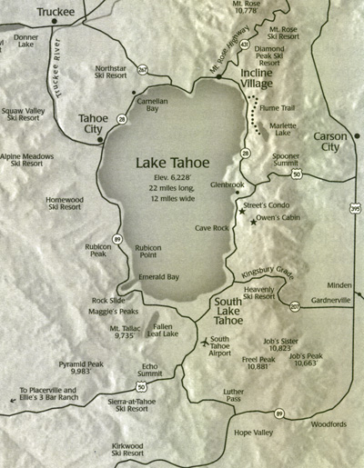
Here is a short tour of the Lake Tahoe area. First, you may want to know a few facts about Tahoe. Elevation: 6,228 feet above sea level. Lake Tahoe is the largest high alpine lake in the Northern Hemisphere. (The only lake in the world that is both bigger and higher is Lake Titicaca on the border of Bolivia and Peru. But it is nowhere as deep or as pure.) Depth: 1,600+ feet. Tahoe is the tenth deepest lake in the world. Size: 22 miles long, 12 miles wide, with a surface area of 140,000 acres. Clarity: Underwater visibility is approximately 70 feet. Weather: Average high temp in January is 40 degrees, average high in August is 79 degrees. Summers are dry with occasional thunderstorms in August. Winters are wet. Precipitation is mostly snow with the West Shore receiving up to 300" per year and the East Shore 150" per year. The mountains receive substantially more. An average year will have 275 to 300 days of sunshine. Water Temperature: Cold! Although the shallow beach areas can warm up to 65 degrees in August, most of the lake stays 40 - 50 degrees year round. Swimmers can easily suffer from hypothermia so wetsuits are advised. Drainage: There are sixty streams that drain into Lake Tahoe. The only outlet is the Truckee River in Tahoe City. The Truckee flows North to Truckee, California, then East to Reno, Nevada and then Northeast to Pyramid Lake. Pyramid Lake has no outlet, its only water loss being evaporation. The map shows the areas immediately adjacent to the lake. Just off the map is Reno to the upper right. San Francisco is 180 miles to the lower left. For those of you who are wondering exactly where Lake Tahoe is in the big picture, remember the "elbow" of California where the east border of the state bends? That elbow is in the middle of the lake.
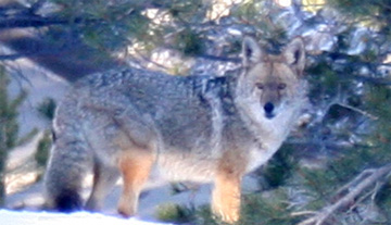
Here's a big healthy coyote looking right into our living room window. |
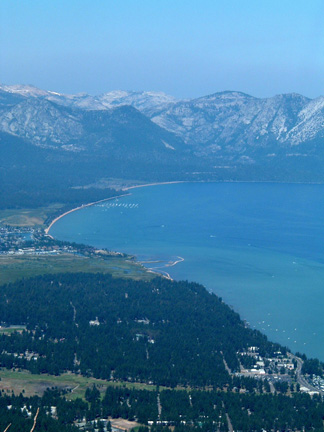
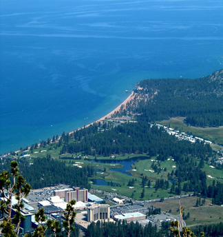
South Lake Tahoe from East Peak at Heavenly. The haze in the air is smoke from lightning-caused forest fires hundreds of miles away in Trinity County in Northern California. |
|
|
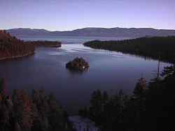
To the left is Emerald Bay on the West Shore, the only bay on the lake. Carved by glaciers during the last few ice ages, it is surrounded by mountain walls that rise up 3,000 feet. If you ever visit you'll see why it is one of the most photographed places in the world. Occasionally, Emerald Bay will freeze over in the winter because, unlike the main lake which is over 1,600 feet deep, Emerald Bay is less than 400 feet deep which allows the water to get a little bit colder than the main lake. Incidentally, while Lake Tahoe never freezes, it also never warms up much in the summer, so if you ever try to swim in it beware of hypothermia! In the middle of Emerald Bay is Fannette Island, the only island in Lake Tahoe. |
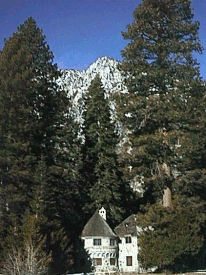
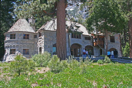
| To the right is the Vikingsholm castle at the head of Emerald Bay. It was built of stone in 1928 by Lora Knight who wanted to duplicate the style of medieval castles in Norway. Every day she had her butler row her out to Fannette Island in Emerald Bay where she climbed up to the stone Tea House to take tea. (Which, of course, the butler carried in a silver teapot.) The Vikingsholm castle puts in an appearance in a few of Owen's adventures. |
|
|
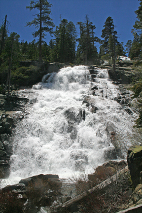
To the right is Emerald Falls. You can get an idea of its size by looking at the 100-foot-tall trees at the top. You reach the best view of the falls by hiking up a well-graded trail from the Vikingsholm Castle at the head of Emerald Bay. However, first you need to hike down to the castle from the parking lot up on the highway. It is a relatively easy one-mile hike that descends 600 feet down to the castle. From there, look for the trail behind the visitor's center. Hike up about a quarter mile and 300 feet of elevation gain to the falls. If the breeze is right, you will stand in a glorious cooling mist below the falls. |
 |
|
|
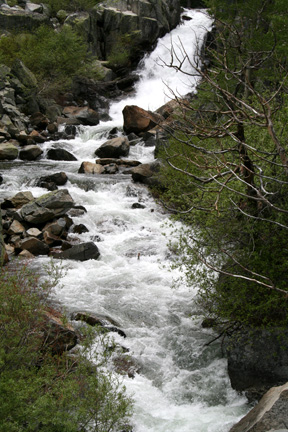
One of the 60 streams rushing spring snowmelt down from the mountains to replenish the waters of the big lake. |
|
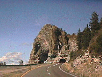
Above is Cave Rock on the east shore of the lake, featured in TAHOE HEAT. Cave rock was and still is a sacred place for the Washoe Indians, the people who lived at Lake Tahoe for thousands of years before the white man named John Fremont "discovered" the Lake. The Washoe wintered to the east down in the Carson Valley and in the summer hiked up to the lake to fish and hunt. Although there is disagreement over the origin of the name "Tahoe," one of the likeliest explanations is that the Washoe called the lake something like "Daow" which means, depending again on the source of information, something like "big water." |
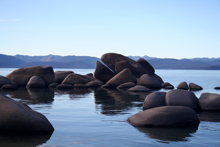
This is the "Whale Jaw" rock near Tahoe's nude beaches. (The location, natch, is a secret. You'll have to sweet-talk a local to get that info.) This rock (along with several of the beaches) is only visible when the water level is low in the fall. There is no road to these areas. Hike-in or boat-in only. |
 |
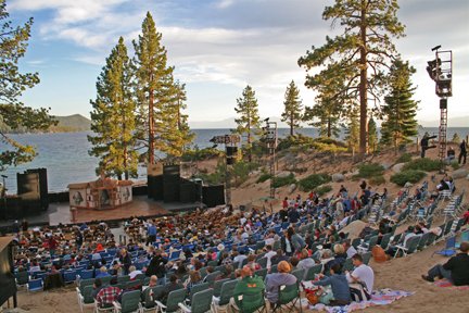
To the left is Sand Harbor on the east shore of the lake, just south of Incline Village. A beautiful crescent of sand beach with brilliant turquoise water, Sand Harbor is where the "Shakespeare on the Beach" festival is held each summer. Imagine relaxing in a sandy natural amphitheater on a summer evening in August while a top-drawer theater company puts on "Hamlet" or "Othello" with moonlit Lake Tahoe as a backdrop. Almost as exciting as earlier in the day when you were lounging on the hot, sunny beach reading an Owen McKenna mystery!! |
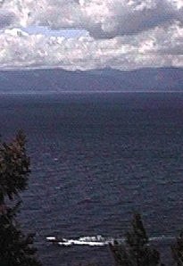
This photo shows Jennifer's big powerboat blasting through the waves with the west shore of Tahoe in the background (a scene from TAHOE DEATHFALL). This view is what Street sees from her condo. |
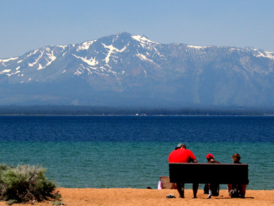
This is what Mt. Tallac looks like from across the lake at Nevada Beach. The haze is more smoke from a distant forest fire. |
 |
To the left in the distance is snow-covered Freel Peak. At the south end of the Tahoe Basin, Freel Peak is Tahoe's highest mountain at 10,881 feet. Freel Peak and the valley below it figure prominently in TAHOE BLOWUP and TAHOE AVALANCHE. |
 |
To the left is a winter wonderland with soft, deep snow perfect for back-country skiing or snowshoeing. Flagpole Peak is in the background. |
|
To the right are Maggie's Peaks just to the southwest of Emerald Bay. On North Maggie's (on the right) is the Rock Slide (see below) where a big part of the mountain slid down toward Emerald Bay in 1955. The Rock Slide is where Melissa Salazar fell to her death in TAHOE DEATHFALL. The rock slide is also where the monster avalanche comes down in the opening of TAHOE AVALANCHE. And yes, the reason these two mountains got their name is exactly what you're thinking!
|
|
|
Below is a picture of the Rock Slide at Emerald Bay with a slight dusting of snow in late fall. The Rock Slide was created in 1955 when a big part of North Maggies Peak broke off and slid down the moutain. The Rock Slide is a place of frequent avalanches. In the winter, CalTrans puts up signs forbidding anyone to even stop. The Rock Slide is prominently featured in TAHOE DEATHFALL and TAHOE AVALANCHE.
|
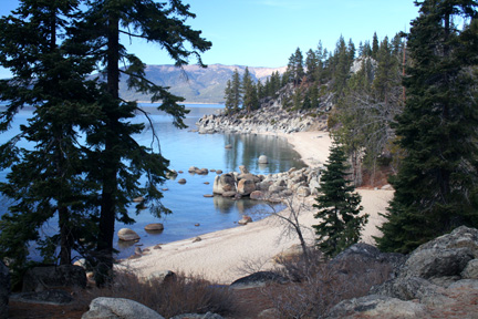
Here are a couple of the hidden beaches on the East Shore. You can't get there except by boat or hiking. The sand disappears when the water is high. |
|
To the right is a view from the Mount Rose highway looking south down the East Shore.
|
|
|
|
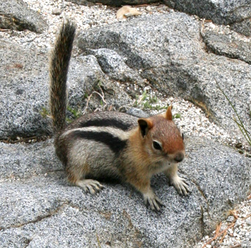
I'm trying to remember what my good friend Jim Stamates, the famous wildlife photographer, said... I think it was, "On chipmunks, the stripe goes through the eye, but not on ground squirrels." I guess this guy's gotta be a golden-mantled ground squirrel. (As you can see, my photos are pretty basic. You can see Jim's amazing work at stamates.com) |
|
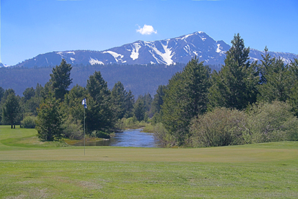
Tahoe has many amazing golf courses all around the lake. This is one of the greens at the Country Club course on Highway 50 between South Lake Tahoe and Meyers. Behind the green is the Upper Truckee River, the largest stream flowing into the big lake. In the distance is Mt. Tallac, the highest mountain directly on the lake and one of the most popular mountains to hike to the summit. Good thing the views are boring so they don't distract you from your putt!
|
|
|
Here's the beautiful silvery water just north of the East Shore's Skunk Harbor where rich, 1920s playboy George Newhall built his stone beach house. It is accessible only by hiking or boating. When George wanted to party, he loaded his friends in his "woody" and took off from his huge estate on the West Shore. The stone beach house also had a separate cookhouse where the cook could whip up a feast for the beach party. After they'd partied and played (and, probably, napped on the sand after consuming their libations in the sun), they took the ten-mile boat ride home. The point of land in the distance is Deadman Point, just south of Skunk Harbor and north of Glenbrook. Like so many of Tahoe's treasures, you can't drive there. You have to get out of your car, work on your hiking-map fluency, and get some high-altitude exercise!
|
|
|
On the East Shore, just south of Incline Village, is Sand Harbor State Park. An amazing collection of turquoise water and sandy beaches, Sand Harbor is also home to Shakespeare at Sand Harbor. Every summer for decades, this natural, sandy amphitheater has been the venue for the most famous plays by the world's most famous playwright. While many Shakespeare lovers are familiar with the Shakespeare Festival in Ashland, Oregon, Tahoe's version is definitely worth taking in. Put on by well-known theatrical companies from across the country, the productions are top-notch. And in case you didn't notice, the view beyond the stage is the best in the world.
|
|
|
|
Do you like to golf? Tahoe's most famous course is Edgewood on the southeast shore. You've seen it and all the celebrities who play at the championship on TV many times. This is the view from 3300 feet up at Heavenly's 9500' East Peak. You get almost the same view from the observation deck when you ride the gondola. |
|
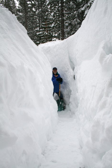
TAHOE'S LEGENDARY SNOW People often wonder if the stories they hear about Tahoe's massive snowfalls are really true. After six weeks of spring-like weather in January and February of 2011, it started snowing almost continuously. The picture to the right shows me shoveling the curved walkway steps from our drive down to our house on March 25th. The walkway sits a foot and a half above the ground. So the snow around our house was over 10 feet deep. It's a laborious process, taking a smallish scoop of snow and throwing it as high as you can. When it gets too deep to throw the snow up, you carry each shovel up the steps to throw elsewhere. Of course, we all use snowblowers to keep our drives clear. Shoveling would be too much. But when your walkway has steps, the snowblower is of no use. The Eastern Shore of Tahoe (called the Banana Belt by locals) gets about a third as much snow as the West Shore. And everywhere down at the lower elevations near the lake, the level areas and areas that slope to the south and west melt off relatively quickly. But the areas that have even a gentle slope to the northeast (like our area at the right) don't melt off until spring. They just keep getting deeper and deeper. The snow you see to the right won't be completely gone until around early June. The higher elevations can easily accumulate snowpacks 40 feet deep. In heavy snow years, the northeast cirques on Pyramid Peak in the Crystal Range, Mt. Tallac, Mt. Rose, Granite Chief, Jobs Sister, will never melt off completely. Incidentally, one fun thing about areas with lasting mountain snow is that you can hike to see "spring wildflowers" for much of the year. At any time, say, late October, you can hike to the base of the remaining snowfields up on the mountains. At the base of a snowfield that has been melting all summer, you will find some moist ground that was continuously covered with snow until within the past week or so. On the moist ground where the snow has just melted, you will often find little wildflowers that have just bloomed on a sunny afternoon. They think it's spring! Little do they know that at any time they will be buried by a snowstorm and covered again for most of the next 12 months.
|
|

Home Books Bio Owen Spot TahoeTour Art Danes Speaking Events Order Contact